Bolted trail "degli Scaloni" - "delle Cavre" - "dell'Anglone"
Fixed rope route • Garda Trentino and Valle di Ledro
Bolted trail "degli Scaloni" - "delle Cavre" - "dell'Anglone"
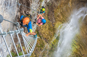
<p>These three bolted trails are fitted with ladders and steel cables and linked to become an easy loop above Dro.</p>
<p>The rocky wall on the right side of the River Sarca, between the villages of Dro and Ceniga, is babded with a system of ledges colonised by holm oak. Up until the years after the Second World War, woodcutters and charcoal burners would scale the steep walls to cut firewood and reach the woods above from where they would send tree trunks and faggots of kindling down to the valley floor by means of rudimentary but effective telpherage wires.</p> <p>The base supporting the telpherage, known locally as le Cavre, gave its name to one of the via ferratas. The other gets its name “Scaloni” (stairway) from the steps made to facilitate the ascent in the most difficult sections. Taken over and refitted by the association Associazione Crozolam, this loop is more of a trail with protection than a via ferrata, but for the sake of safety you still need to wear a helmet, harness and ferrata set.</p>
Bolted trail "degli Scaloni" - "delle Cavre" - "dell'Anglone"

Garda Trentino Verified partner
-
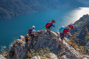
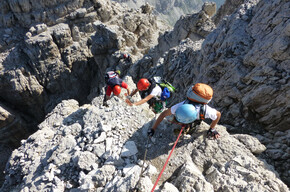
 Bolted trails Scaloni / Cavre / AnglonePhoto: Elaborazione grafica Sveva Seneci, Garda Trentino
These three bolted trails are fitted with ladders and steel cables and linked to become an easy loop above Dro.
The rocky wall on the right side of the River Sarca, between the villages of Dro and Ceniga, is babded with a system of ledges colonised by holm oak. Up until the years after the Second World War, woodcutters and charcoal burners would scale the steep walls to cut firewood and reach the woods above from where they would send tree trunks and faggots of kindling down to the valley floor by means of rudimentary but effective telpherage wires.
The base supporting the telpherage, known locally as le Cavre, gave its name to one of the via ferratas. The other gets its name “Scaloni” (stairway) from the steps made to facilitate the ascent in the most difficult sections. Taken over and refitted by the association Associazione Crozolam, this loop is more of a trail with protection than a via ferrata, but for the sake of safety you still need to wear a helmet, harness and ferrata set.
Author’s recommendation
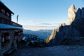
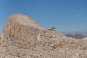
The old bivouac Crozolam has been restored and it is now part of th Parco Crozolam, a park that show the local history and culture linked to the wood economy.
Garda Trentino Verified partner
Derived from the technical difficulty and the stamina requirements.
Track types
Safety information
Safety Tips
Choose the route based on your actual psycho-physical preparation, technical ability, and experience. Always assess the conditions of crowding, weather, the state of the fixed equipment, and the route. The final decision and responsibility for the passability of the route lie entirely with the person who decides to undertake it. If you are unsure, seek information or rely on qualified professionals.
- Only do the via ferrata if you are reasonably fit and in excellent health.
- Use proper safety gear (helmet, harness, ferrata kit with double selflocking carabiners and energy absorbing systems). Put on your helmet once you get near to the wall in case of rock falls.
- Check the weather report and do not undertake the via ferrata ascent in adverse weather conditions, especially in the event of a thunderstorm threat.
- The risk of rock falls increases if there are others on the via ferrata or with wind or rain.
- During progression always keep both carabiners clipped onto the safety cable and when you pass the anchor points make sure at least one carabiner is clipped on to the metal cable.
- Only one person may be on any length of cable between two anchor points.
- Always check route conditions; in winter you may find snow and ice, making progress very dangerous.
- Do not do the via ferrata alone: if you have an accident nobody will be able to call for help.
Emergency telephone number 112.
The information on this chart is subject to inevitable variations, so this means that none of the indications are absolute. It is not entirely possible to avoid giving inexact or imprecise information, given how quickly environmental and weather conditions can change. For this reason, we decline any responsibility for changes which the user may encounter. In any case, the hiker is advised to check the conditions of the places, environment and weather before setting out.
Tips and suggestions
Via ferratas are no joke – cables, ladders and dizzying views demand the right gear and know-how. Count on our via ferrata specialists: alpine guides, rentals and shops with everything you need to climb safely.Roadbook
Access
From the Roman Bridge in Ceniga follow the road towards Maso Lizzone(NO car park). Take the SAT428 trail to the left, then turn right after a farmhouse and continue until you reach the Anglone crag.
Route
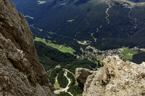
With short stretches over boulders and a partially exposed trail you come to a sequence of broad steps (1) and an easy chimney, which lead to a slab with steps carved into the rock. After a section of trail, you come to a series of stone steps and the final trail which leads to Dos Tondo.Here you are at the junction with the trail SAT428B Delle Cavre: head north along it to the Crozolam shelter and continue on the path SAT425 until the bolted trail Sentiero dell’Anglone, which first descends onto a rocky slab and then, through a series of chimneys and easy rocks, leads down to wide steps, which take you to the foot of the wall.
Return
Towards Ceniga, first take the Molinei track and then the Campagnola track along the river Sarca.
Bike/E-Bike Stop Centro Sportivo Oltra - Dro
Public transport
Public-transport-friendly
Dro and Ceniga are connected by the intercity bus lines 205 (Riva del Garda – Sarche - Trento) and 204 (Riva del Garda– Cavedine - Trento) to the other places in Garda Trentino.
Up-to-date information on timetables and routes.
Get Timetable to destination
Directions
From Arco follow the SS45bis road in the direction of Ceniga.
Find out how to reach Garda Trentino.
Parking
Free parking along Via Arco in Ceniga.
Coordinates
Author’s map recommendations
Garda Trentino TREKKING Map – Available in the info points of Garda Trentino (Riva del Garda, Arco, Torbole sul Garda, Ledro, Comano Terme)
Equipment
You need to wear the right clothing and take the proper gear when you go hiking in the mountains. Even on relatively short easy outings make sure to take all you need so you don't run into trouble if things take an unexpected turn, for example a storm blows up or you have a sudden drop in energy levels.
What should you absolutely have with you on a via ferrata tour?
- rucksack (25/30L capacity) for a day trip
- technical mountain clothing
- hiking boots with Vibram or similar sole
- via ferrata gear
- harness
- helmet
- gloves
- pickaxe and crampons (when necessary)
- a length of rope (recommended)
Derived from the technical difficulty and the stamina requirements.
Weather at the starting point
Statistics
You may also like ...