Vine landscapes
Hiking trail • Altopiano di Pine' and Valle di Cembra
Vine landscapes
<p>A quintessential Val di Cembra route: villages perching on steep hillsides, terraced vineyards, Avisio stream, Segonzano castle</p>
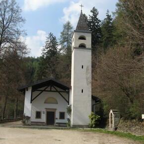
<p>This route starts in the centre of Faver and crosses through the town following European footpath E5 signs for Via storica della Corvaia which descends to Cantilaga bridge on the Avisio stream, for centuries the only road access between the two banks of the stream.</p> <p>Along the descent the cobbled mule track passes “Capitello della Madonna delle Grazie”. Legend has it that this was the place of the Om Selvàdech (wild man), a sort of gnome who had fun springing out of the forest to frighten local women as they passed by, shouting and yelling as he pursued them.</p> <p>It then emerges at Ponte di Cantilaga, cited for the first time in 1472 and destroyed in 1630 to stave off the plague which was raging on the Faver side of the stream. It was then rebuilt several times before the current bridge was put up in 2007. At Ponte di Cantilaga the route turns right towards Piazza. In the area of the graveyard a detour to the left takes you to the ruins of medieval Segonzano castle.</p> <p>It then descends to Piazzo whose Chiesetta dell’Immacolata, built in the year 1500 in late Gothic style above an earlier chapel dating to around 1130, is worth visiting. It contains a fine wooden Madonna dell’Uva statue. From Piazzo the route descends on a provincial road to Ponte dell’Amicizia on the Avisio stream. After the bridge the route turns immediately left onto a minor road along the stream and Returns to Faver on country roads through terraced vineyards.</p>
