Toprecommended route
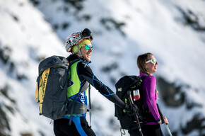
Back-country skiing
· Val di Fassa
Ski mountaineering at Cima Undici - Val dei Monzoni
Responsible for this content VisitTrentino
Verified partner
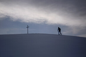
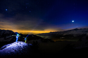
It's time to go down and the skins are removed
Photo: VisitTrentino
Selected alternatives for you
Classic route with magnificent views of the Dolomites of Fassa
moderate
Distance 15.6 km
Duration3:58 h
Ascent1,075 m
Descent1,076 m
Highest point2,496 m
Lowest point1,420 m
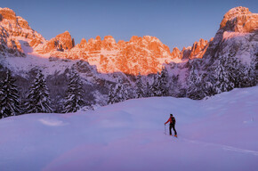
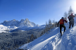
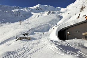
The excursion to Cima Undici is a splendid route that leads into the upper Val dei Monzoni, a secluded corner of Val di Fassa. The first part up to Malga Monzoni takes place on a snowy road for sledding, while in the upper part the forest gives way to wide slopes, never too steep. The malga is a good intermediate refreshment point, and the Vallaccia refuge higher up is often open on winter weekends.
Author’s recommendation
In the descent section between the Vallaccia refuge and the Malga Monzoni, it is possible to freely descend through the forest instead of staying on the road.
Author
VisitTrentino
Responsible for this content
VisitTrentino
Verified partner
Difficulty
moderate
Overall difficulty
moderate
Derived from the technical difficulty and the stamina requirements.
Experience
Landscape
Highest point
2,496 m
Lowest point
1,420 m
Best time of year
Jan
Feb
Mar
Apr
May
Jun
Jul
Aug
Sep
Oct
Nov
Dec
Cardinal direction
Track types
Show elevation profile
Safety information
The final section is often subject to wind deposits, so carefully assess the avalanche danger.
As you can imagine, the passability of routes in a mountain environment is strictly linked to the current conditions and therefore depends on natural phenomena, environmental changes, and weather conditions. For this reason, the information contained in this sheet may have changed. Before leaving, check the status of the route by contacting the managers of the refuges on your route, alpine guides, visitor centers of natural parks, and tourist offices.
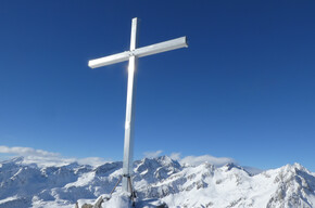
From the Soldanella restaurant, return across the bridge and take a forest road on the left (snowmobile track) that with some ups and downs leads to Malga Crocifisso at 1525m. From here, take the road that goes up to Val dei Monzoni to the homonymous malga (farm stay open also in winter), then continue towards the Vallaccia refuge following the signs of the summer SAT trail 624. Beyond the refuge, around 2350m you reach a crossroads with summer signs at the base of a steep small valley channeled on the right. Climb it up to the upper plateau, then cross decisively to the right up to the summit ridge which shortly leads to Cima Undici.
Rest stop
Tip
Nearby
Top Partner
Waypoint
Start point
End point
Low point
High point
Forecast
Today {low} to {high} and {precipitation} of {precipitation_type}
show {x} more
Photo
Video
Public transport
no
Directions
From Pozza di Fassa follow the signs for Val S.Nicolò up to the Soldanella restaurant, at a bridge over the Rio S.Nicolò.
Parking
Without occupying the restaurant parking spaces, it is possible to park in the large clearing just before the bridge, right in front of the forest road where you start skiing.
Coordinates
DD
46.420402, 11.705503
DMS
46°25'13.4"N 11°42'19.8"E
UTM
32T 707897 5144315
w3w
///helicopter.helpful.liked
Get there by train, car, bike, or on foot!
Book recommendation by the author
Ski mountaineering excursions in Fiemme, Fassa, and Primiero - Marco Bozzetta publisher
Author’s map recommendations
4Land no.133 - Val di Fassa
Equipment
For mountain excursions in winter, appropriate clothing is recommended even in case of sudden temperature drops. Gloves, hat, sunglasses, and sunscreen should also be part of the usual equipment. It is also important to have suitable footwear that keeps the feet warm and does not get wet in contact with the snow.
For trips on snowy terrain, it is also advised to always have an avalanche self-rescue kit consisting of ARTVA-shovel-probe (can also be rented).
Localization
Parts of this content were machine translated using Italian as the source language
Similar routes nearby
Juribrutto Peak
Castelir - Canvere
Bocche Peak
Caladora da Val Venegia
Piccolo Colbricon
These suggestions were generated by our system
Difficulty
moderate
Overall difficulty
moderate
Derived from the technical difficulty and the stamina requirements.
Distance
15.6 km
Duration
3:58 h
Ascent
1,075 m
Descent
1,076 m
Highest point
2,496 m
Lowest point
1,420 m
ScenicRefreshment stops availableSummit route
Avalanche conditions
most recent, highest rating{numRegions} bulletins: highest rating{numRegions} bulletins: most recent, highest danger levels