Tour de Non MTB Experience: Tappa 03 Malga di Romeno - Sporminore
Mountainbiking • Val di Non
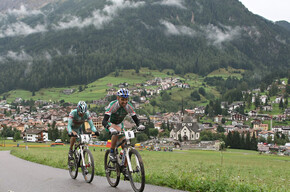
Tour de Non MTB Experience: Tappa 03 Malga di Romeno - Sporminore
<p><strong>DAL PUNTO PIU’ ALTO DEL TOUR IN PICCHIATA VERSO SUD</strong></p> <p> </p>
<p>Si inizia questa tappa in stile “bike&hike” ed ecco che ci si ritrova sul tetto del Tour de Non. Alla cima del Monte Roen i bikers non hanno raggiunto solo la montagna più alta della massicciata della Mendola ma anche il punto più alto di questo alpencross di 4 giorni. Da questo ineguagliabile punto panoramico non sfugge nulla: ai piedi dello strapiombo la Val d’Adige e la Strada del Vino di Caldaro, ad est le cime dolomitiche dal gruppo del Sella fino alla Marmolada, a nord la grandiosa massicciata con le Alpi di Tux e Stubai, ad ovest le Dolomiti di Brenta con ai suoi piedi l’ampia Val di Non. Mettiamola così, in questa tappa si raccolgono i frutti di tutte le fatiche dei giorni precedenti. Più in alto di così non si può andare e quindi ora ha il via una lunghissima discesa sempre in cresta e lungo il confine culturale e linguistico tra Trentino e Alto Adige. Solo dopo un lungo tratto si arriva al Passo Predaia e qui si abbandona la cresta in direzione ovest per atterrare sui morbidi e verdi prati della Predaia. Su single trails a tratti molto scorrevoli e a tratti dissestati finalmente si raggiungono anche i paesi e le loro genti. Da questo punto di vista ci si rende conto solo ora che il giorno precedente era trascorso in un ambiente così solitario e sperduto.</p> <p>Prima di intraprendere la lunga attraversata in uno dei tanti canyon che scavano la Val di Non e di raggiungere il medievale Castel Thun nella parte bassa della valle ci si lascia piacevolmente sorprendere da una chicca imperdibile che solo alcuni bikers del posto conoscono: “Amedeo super flow trail”, un single trail unico nel suo genere, un dono di madre natura che regala ai bikers divertimento puro scendendo dal Rifugio Sores fino a Vervò. Ci sono stati bikers che, con le lacrime agli occhi, hanno risalito i 200 metri di dislivello sulla strada asfaltata per poter scendere nuovamente questo trail! La prima volta che lo si percorre non si riesce a credere come questo sentiero sia perfettamente modellato nel paesaggio. E alla seconda volta un’esclamazione nasce spontanea: QUESTA deve essere stata mano del creatore dell’universo dei bikers!</p>
Tour de Non MTB Experience: Stage 03 Malga di Romeno - Sporminore

APT Val di Non Verified partner
-
 Photo: Silvia Gentilini, APT Val di Non
FROM THE HIGHEST POINT OF THE ROUTE, STEEP DESCENT TOWARDS THE SOUTH
This stage starts in “bike&hike” style and here you find yourself on the roof of the Tour de Non. At the summit of Monte Roen, bikers have reached not only the highest mountain of the Mendola massif but also the highest point of this 4-day alpine cross. From this unparalleled panoramic point, nothing escapes: at the foot of the cliff is the Val d’Adige and the Caldaro Wine Road; eastward, the Dolomite peaks from the Sella group up to Marmolada; to the north, the grand massif with the Tux and Stubai Alps; to the west, the Brenta Dolomites with the wide Val di Non at their feet. Let’s put it this way: this stage gathers the fruits of all the efforts of previous days. One cannot go higher than this, and now begins a very long descent always along the ridge and along the cultural and linguistic border between Trentino and Alto Adige. Only after a long stretch do you reach Passo Predaia, where the ridge is left towards the west to land on the soft and green meadows of the Predaia. On single trails, sometimes very smooth and sometimes rugged, you finally reach the villages and their people. From this perspective, you realize only now that the previous day was spent in such a solitary and remote environment.
Before undertaking the long crossing in one of the many canyons carving the Val di Non and reaching the medieval Castel Thun in the lower part of the valley, you can be pleasantly surprised by an unmissable gem known only to some local bikers: “Amedeo super flow trail”, a unique single trail of its kind, a gift from mother nature offering pure fun to bikers descending from Rifugio Sores down to Vervò. Some bikers, with tears in their eyes, have climbed back the 200 meters of elevation on the paved road just to descend this trail again! The first time you ride it, you can hardly believe how perfectly this path is shaped in the landscape. The second time, an exclamation spontaneously arises: THIS must have been the hand of the creator of the universe of bikers!
Author’s recommendation
3 REASONS NOT TO MISS THE STAGE
1. The privilege of being the first to reach the panoramic summit of Monte Roen in the morning
2. The panoramic single trail along the ridge from Passo della Mendola towards Graunerjoch
3. The incredible "Amedeo super flow trail", pure fun shaped by mother nature
APT Val di Non Verified partner
Derived from the technical difficulty and the stamina requirements.
Track types
Rest stops
Hotel Rifugio SoresRistorante Solarium Predaia
Ristorante Al Lago
Agritur Sandro
Ristorante Rifugio "Ai todes ci"
Malga Rodeza di Tres
Safety information
Please note that the practicability of the itineraries in a mountain environment is strictly linked to the contingent conditions and is therefore influenced by natural phenomena, environmental changes and weather conditions. For this reason, the information contained in this page may have changed. Before leaving for a tour, make sure the path you will approach is still accessible by contacting the owner of the mountain hut, the alpine guides or the visitor centres of the nature parks, the info offices of the local tourist board.Tips and suggestions
Go to the stage on the official Tour de Non site
38% single trail
38% unpaved
21% asphalt
3% bike pushing
Roadbook
The stage starts at Malga di Romeno (1770 m) with a steep forest road heading towards the summit of Monte Roen (2112 m). It is 2 kilometers from the malga to the summit with an elevation gain of 340 m: how much of this section you can ride depends greatly on the biker’s strength, technique, and conditions. Even the most trained bikers should reckon with about an hour of travel because half of this must be done pushing the bike. Already at 1860 m the road becomes extremely steep, and after 1 km it turns into an increasingly rough dirt road. You continue pushing your bike through the grassy slope strewn with dwarf pines until you reach the ridge of the Mendola range with the recognizable cross on the summit of Monte Roen a bit further ahead, where you take a well-deserved break in front of a sensational panorama. Leaving Malga di Romeno early in the morning has the great advantage of allowing you to be the first to reach the top and enjoy the environment and the panorama alone. Trail runners, hikers, and other bikers routinely visiting Monte Roen at that hour are still on the way and crowd the summit while we are already projected into the very long single trail characterizing today’s stage.
The continuation of the single trail “Costiera della Mendola” for 2.8 km southwards takes place entirely on SAT path number 500, which is almost completely rideable for a biker with good technique. However, this trail has two delicate descending sections with very eroded ground where we ask you to push the bike (a first 120 m section and a second 250 m section). The first critical passage is reached already at km 2.3, just a few meters after the summit cross of Monte Roen where the trail abruptly drops steeply between dwarf pines into an eroded groove with a gravelly and uneven bottom. A clean and respectful ride of the bike is barely possible even for those with very good riding skills, so we believe pushing the bike is the most sensible behavior to avoid further damage to the trail surface and to ensure the safety of hikers climbing up. The second delicate passage has the same features as the first one just described and is located at km 3.7 near Testa Nera before the descent towards Bocca di Val Calana. Here too, a gravelly groove has formed and the trail proceeds left along the ridge where it is very exposed in some parts. For safety reasons and also to respect this already heavily compromised trail and to avoid endangering passing hikers, we ask you also here to push your bike for a short section downhill. Except for the two sections described above, the rest of the ridge trail along the Costiera della Mendola from Monte Roen to Bocca di Val Calana (4.8 km) though narrow is fully rideable for a good biker. With proper body involvement, it is possible to overcome even shorter flat and uphill parts in the saddle. Since the trail mainly runs through dwarf pine woods where visibility is limited, it is necessary to moderate your speed as this trail is naturally also frequented by hikers, who always have right of way.
From Bocca di Val Calana onwards, the trail becomes wider, rises a couple of meters, and then continues along the ridge without significant loss of elevation. You pass the forest road at Grauner Joch (6.3 km, 1799 m) and shortly after at km 6.7 you reach a small hut with a nice view of Val d’Adige. Now you enter a meandering descending single trail down to the shrine of Santa Barbara (7.6 km) before at km 7.9 a ramp towards the summit of Grauner Joch forces you to dismount and push your bike. The trail now continues with ups and downs (...). You remain always on the ridge trail and without being tempted by other more beaten and evident tracks on the right which would lead unnecessarily downwards. At Roccia Larga (9.2 km), once again you approach the dizzying edge of the rock wall towering over Val d’Adige that also marks the border with South Tyrol before finally leaving the ridge trail at km 9.8 (before the ramp ascending Corno del Cervo) to head west towards the welcoming Malga Rodeza (10.6 km) where you enjoy a well-deserved break at this well-managed and recently renovated malga.
The descent from Malga Rodeza to Rifugio Predaia Ai Todes’ is entirely on a dirt forest road. At km 12.6 (1400 m) you leave it and before the refuge turn right on a dirt road along the slope of the Predaia plateau. Immediately this dirt road introduces the single trail “Prati Predaia” which with some rugged sections crosses the forest and then leads us near a small ski lift facility in the middle of lush meadows. At the ski lift building (14.5 km, 1256 m) you enter the paved road and head south to the Sores Adventure Park beside Rifugio Sores (15.5 km, 1203 m). At the crossroads, you keep right downhill for 500 meters until you notice a dirt road on the left near a hairpin bend of the paved road descending right (16.0 km, 1142 m). You take that dirt road and after 150 meters sharply turn right onto a forest track that immediately becomes a steep but very fast single trail. From around km 17.0, the Amedeo Super Flow Trail captivates every biker: the trail winds in a series of curves along the gentle slope of a pine forest without obstacles, difficulties or hindrances. A perfect flow trail created by nature where, like in a pump track, you face and overcome its parabolic curves working only with your body. The trail ends in a pine forest in the upper part of the village of Vervò (Vervasio, 17.8 km, 950 m).
We continue the route keeping left, initially passing on a descending path to the picnic area “Verginaz” (18.1 km, 935 m). From here, you turn left onto a dirt road leading into the valley formed by the Rio Pongaiola canyon, crossing it thanks to a bridge that takes you to the other side of the valley (20.1 km, 823 m). Now you are on the Frassati trail ascending towards Malga di Vervò. Since this malga does not offer catering, it remains on our left (22 km). The dirt road reaches its highest point of 1050 meters at Val Marzana at km 23.5. You then descend quickly through the forest until you find a crossroads at km 25.8. You go straight on for the next 600 meters (the right fork and the subsequent left fork would also take you to Castel Thun). At km 26.4, a dirt road joins our descent from the left. Just at this point, a small path is hidden on the right! A wooden sign, almost hand-carved, introduces a passage towards the castle. We follow this path descending through dense and sometimes steep forest (alternatively, you can follow the dirt road which shortly becomes a cement ramp). The recommended descent on the right is better and develops on a technically difficult trail and after 500 meters it leads to a dirt road which we follow turning left. Shortly ahead, you find a very beautiful panoramic spot with an explanatory plaque overlooking Castel Thun and the valley (28.7 km). Now the single trail “Rocce di Castel Thun” suddenly shows all its character in the form of rock slabs, scree, and steepness. After about 300 meters, the rebellious trail is tamed and continues smoothly up to the beginning of the apple orchards near Bolgina (28.3 km, 534 m). Once you reach the farm road, turn left and ascend slightly to reach Nosino, the village at the foot of the imposing Castel Thun. In Nosino (28.9 km) you bypass the northern and eastern slopes of the hill on which the castle stands, passing in front of the small chapel of San Martino up to the visitors’ parking of the castle (29.4 km).
Whoever wishes to take a break and visit the castle can follow the gpx track leading to the main entrance of the manor on the north side of the castle (30.0 km). You can visit the outer courtyards and gardens for free, where there is also a café.
The track leads us to leave the castle descending comfortably on dirt roads among the orchards and passing along the Frassati Path and part of the Camino Jacopeo d’Anaunia, then heading south towards the valley end where the Noce stream has carved a narrow passage in the canyon near Rocchetta (37 km), opening southwards towards Piana Rotaliana and the town of Mezzolombardo. The same passage is unavoidable for us bikers because the stream cannot be crossed elsewhere in this area. Unfortunately, this means we have to share the traffic of the provincial road for less than a kilometer before reaching again the quiet farm roads among the orchards at Maso Milano (38.7 km), already on the other side of the Noce river. After a steep climb of the terrain, we reach the famous “Dolomiti di Brenta Bike” trail near Sporminore (41.7 km).
VARIANTS AND ADVICE
Trail “Costiera della Mendola”: to be avoided in case of adverse weather conditions to avoid unnecessary risks. There are several exit options:
- A road, first unpaved then paved, descends from Malga di Romeno to the villages of Amblar and Cavareno where it meets the Alta Val di Non cycle path
- A second forest road leads from Malga di Romeno to the malgas of Amblar, Don and Sanzeno and also in this case descends towards Don and Amblar but through a variant (sign 537) in the Rio Verdes canyon up to the Hermitage of San Romedio (here you can connect to the “easy” version of the Tour de Non)
- If you find yourself already on the “Costiera della Mendola,” in case of difficulty, you can leave it at the Bocca di Val Calana (4.8 km), or at Passo Predaia (8.4 km) heading towards Malga di Coredo (managed refreshment point).
ROADBOOK STAGE 03
Km Altitude
0.0 1766 Malga di Romeno, take the steep dirt road (sign 500) uphill towards Monte Roen. After 1 km it becomes extremely steep, possibly push the bike.
2.0 2111 Summit of Monte Roen, continue on path 500 southwards (Testa Nera)
2.2 2098 Steep descending path on slippery ground, please push the bike for about 150 meters, elevation difference about 40 meters
2.4 2052 Narrow but rideable path, please proceed slowly paying attention to pedestrians.
3.7 2028 Testa Nera (Schwarzopf), steep gravelly and sometimes exposed descent. Please push the bike for about 200 meters to avoid further trail erosion and out of respect for pedestrians. Elevation difference about 80 meters.
4.0 1942 Rideable single trail to Bocca di Val Calana, initially among dwarf pines and then in the forest. Proceed slowly paying attention to hikers coming the opposite way.
4.8 1840 Bocca di Val Calana, short change in slope with a short climb. Then follows a mostly flat dirt road towards Grauner Joch.
6.3 1799 Grauner Joch, ignore deviations and continue southwards on path 500.
6.7 1807 Kuhlegerhütte hut, nice panorama. Then a steep single trail with many curves to Croce di Santa Barbara.
7.6 1690 Croce di Santa Barbara, stay on the ridge.
7.9 1660 Change in slope before Giogo di Graun, continue uphill on the ridge and push the bike for about 40 meters (or alternatively turn right to take the dirt road descending to Malga di Coredo (managed refreshment point).
8.4 1655 Steep single trail descent towards the hollow at Passo Predaia, continue uphill along the ridge pushing for about 20 meters (or take the dirt road on the right towards Malga di Coredo).
9.2 1650 Roccia Larga, steep path descent towards the next saddle (9.5 km, 1600 m), then continue on the ridge on path 500 and push uphill for about 20 meters.
9.8 1624 At Corno del Cervo leave the ridge path 500 and descend right on a dirt road for 100 meters then turn left onto sign 526 towards Malga Rodeza.
10.6 1575 Malga Rodeza (managed refreshment point). Continue on forest road towards Predaia.
12.6 1405 Refugio Predaia, leave forest road to take a dirt road on the right through the meadows. Road then turns into rugged single trail.
14.1 1296 At the ski lifts, descend left towards the Predaia Park building, then reach the parking lot on the paved road.
14.5 1256 Passo Predaia, follow the paved road south towards Rifugio Sores and Vervò.
15.5 1206 Sores Adventure Park, head right downhill for 500 meters towards Vervò.
16.0 1142 Near the right hairpin, leave the paved road, take a dirt road on the left and follow it for 200 meters slightly uphill.
16.2 1160 Crossroads in a clearing, turn right on the dirt road that becomes single trail (Amedeo Super Flow Trail) towards Vervasio and Vervò. Follow the colored signs carefully!
17.8 952 Single trail emerges into a pine forest near Vervasio, keep clearly left following the mountainside and proceed along the slightly uphill path.
18.1 934 Locality Verginaz, the single trail ends in a picnic area; follow the dirt road left towards the Rio Pongaiola canyon and towards Malga di Vervò (always stay on the main road).
20.1 826 Rio Pongaiola, the crossing on the bridge corresponds to the lowest point of the canyon, from here the ascent resumes.
22.0 1008 Ignore all deviations, including those for Malga di Vervò (which is not managed). Continue on the Frassati path towards Castel Thun.
23.5 1053 Val Marzana, highest point along the forest road.
25.8 904 At the junction, turn right downhill for 600 meters (do not continue straight towards Castel Thun, there is an unpleasant cemented descent!).
26.4 861 At the bifurcation of the left curve continue in the forest, the road becomes more and more a trail.
27.5 700 The road becomes a trail, further on there is a panoramic terrace overlooking the castle and delicate passages on rough and rocky trail.
28.3 535 At the entrance to the road among orchards, turn left towards Nosino.
28.9 556 Nosino, cross straight through the village and pass the small chapel of San Martino at the foot of the castle.
29.4 554 If you want to visit the castle: at the car park entrance keep left and take the access road that bypasses the hill where the castle stands until you reach the main entrance on the north side of the castle.
30.0 587 Castel Thun, north access. From the north access of the castle continue westwards along the path descending to the parking lot.
30.3 555 From the parking lot take the climb, but immediately after 40 meters take the second small road on the right descending through the orchards (after the no car access sign). The farm road stays on altitude. Attention: when crossing the orchards, pay attention to junctions and strictly follow the gpx track!
30.9 540 At a junction keep left, staying roughly at the same altitude.
31.1 537 Leave the main track heading right, then go straight downhill on a rough farm road. This stays on the left.
31.2 506 The track curves left and ends in a small forest, shortly after a steep climb.
31.3 522 After the steep passage the path ends on a dirt road, follow it straight then along the right hairpin downhill.
31.4 518 At the crossroads after the hairpin descend right for 200 meters.
31.6 493 At the crossroads turn sharply left (leave the main track in the village of Ton) and now continue following the Frassati path. Also watch out for the signs of the Camino Jacopeo d’Anaunia with the yellow shell.
33.4 545 Maso della Pozza, continue on Frassati path/Camino Jacopeo.
35.0 415 Masi di Vigo, continue on Frassati path/Camino Jacopeo.
35.8 322 Ceramica, you come out just below the locality on the paved SP124 road, follow it left downhill to the main road SP73.
36.0 303 At the entrance of SP73, follow it left to La Rocchetta.
37.0 250 Attention: crossing the busy junction at La Rocchetta is a bit complicated because in the narrow canyon passage several roads converge. We make a turn of almost 270° in which the exit is lower than the entrance. First, you turn left and then leave the turn to take on the right a short 100-meter illuminated tunnel.
37.7 265 Ignore the junction on the left towards Andalo and Spormaggiore, continue straight on SS43.
38.7 260 Take the left junction towards Maso Milano and cross the locality in a traffic-free area.
39.7 283 Cross the bridge on the left, pass the fish farm and restaurant Baita Marinara and continue uphill.
40.9 380 Tre Tini, pass the farmhouse keeping right on a dirt road (attention to the beehives behind the building!)
41.4 355 The track makes a right curve over a bridge and then continues again right but upwards.
41.7 372 The path enters the “Dolomiti di Brenta Bike”, follow this route uphill to the right. Some steep climbs until Sporminore.
43.4 531 Sporminore village
Coordinates
Derived from the technical difficulty and the stamina requirements.
Weather at the starting point
Statistics
You may also like ...
")


")

")