Via Ferrata Colodri - Colt
Fixed rope route • Garda Trentino and Valle di Ledro
Via Ferrata Colodri - Colt
<p>Easy route up the east wall of Monte Colodri alongside the overhangs, with a spectacular view on the Valley of river Sarca. A classic of Garda Trentino! </p>
<p>The east face of Colodri witnessed the birth of free climbing in Arco in the seventies and eighties when the first modern routes were freed and it became a reference point for the first climbers.</p> <p>The bolted trail was created as a descent trail for the hundreds of climbing teams that scale the sheer walls.</p> <p>It is easy to get to, relatively simple and has a handy descent trail which makes it the perfect place for anyone approaching the vertical world for the first time. In fact it has quickly become the most popular via ferrata in Garda Trentino for beginners and families.</p> <p>Put on your helmet, harness and ferrata set, and in a few minutes from Prabi you are at the start of the ferrata. After a section with cable and steps, you come to a smooth wall which is the baptism by fire for the absolute beginner: the rungs and safety cable will help you overcome any fear. Shortly before the top there is one last vertical stretch fitted with rungs for an exciting finish.</p> <p>From the summit of Monte Colodri the view stretches from the Castle rock over the entire vale of Garda Trentino. </p>
Via Ferrata Colodri - Colt

Garda Trentino Verified partner
-
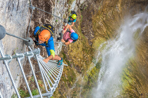
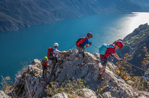
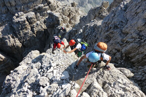
 Colodri via ferrataPhoto: Archivio Garda Trentino (ph. Watchsome), Garda Trentino
Easy route up the east wall of Monte Colodri alongside the overhangs, with a spectacular view on the Valley of river Sarca. A classic of Garda Trentino!
The east face of Colodri witnessed the birth of free climbing in Arco in the seventies and eighties when the first modern routes were freed and it became a reference point for the first climbers.
The bolted trail was created as a descent trail for the hundreds of climbing teams that scale the sheer walls.
It is easy to get to, relatively simple and has a handy descent trail which makes it the perfect place for anyone approaching the vertical world for the first time. In fact it has quickly become the most popular via ferrata in Garda Trentino for beginners and families.
Put on your helmet, harness and ferrata set, and in a few minutes from Prabi you are at the start of the ferrata. After a section with cable and steps, you come to a smooth wall which is the baptism by fire for the absolute beginner: the rungs and safety cable will help you overcome any fear. Shortly before the top there is one last vertical stretch fitted with rungs for an exciting finish.
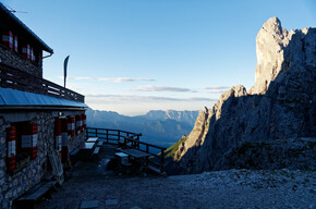
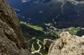
From the summit of Monte Colodri the view stretches from the Castle rock over the entire vale of Garda Trentino.
Author’s recommendation
In 1986 the Colodri wall was the venue for the first edition of Sport Roccia which would later become RockMaster.
Garda Trentino Verified partner
Derived from the technical difficulty and the stamina requirements.
Track types
Safety information
Safety Tips
Choose the route based on your actual psycho-physical preparation, technical ability, and experience. Always assess the conditions of crowding, weather, the state of the fixed equipment, and the route. The final decision and responsibility for the passability of the route lie entirely with the person who decides to undertake it. If you are unsure, seek information or rely on qualified professionals.
- Only do the via ferrata if you are reasonably fit and in excellent health.
- Use proper safety gear (helmet, harness, ferrata kit with double selflocking carabiners and energy absorbing systems). Put on your helmet once you get near to the wall in case of rock falls.
- Check the weather report and do not undertake the via ferrata ascent in adverse weather conditions, especially in the event of a thunderstorm threat.
- The risk of rock falls increases if there are others on the via ferrata or with wind or rain.
- During progression always keep both carabiners clipped onto the safety cable and when you pass the anchor points make sure at least one carabiner is clipped on to the metal cable.
- Only one person may be on any length of cable between two anchor points.
- Always check route conditions; in winter you may find snow and ice, making progress very dangerous.
- Do not do the via ferrata alone: if you have an accident nobody will be able to call for help.
Emergency telephone number 112.
The information on this chart is subject to inevitable variations, so this means that none of the indications are absolute. It is not entirely possible to avoid giving inexact or imprecise information, given how quickly environmental and weather conditions can change. For this reason, we decline any responsibility for changes which the user may encounter. In any case, the hiker is advised to check the conditions of the places, environment and weather before setting out.
Tips and suggestions
Via ferratas are no joke – cables, ladders and dizzying views demand the right gear and know-how. Count on our via ferrata specialists: alpine guides, rentals and shops with everything you need to climb safely.Roadbook
Access
In Prabi take the trail in front of the car park of the municipal swimmingpool, which leads you to the foot of Monte Colodri and in a few minutes to the start of the ferrata.
Ascent
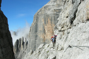
The start of the via ferrata is located at the top of the boulder cone at the base of the east wall of Mount Colodri. After an initial easy equipped ledge, the route ascends by crossing to the left along ledges interspersed with short vertical walls equipped with fixtures, until reaching the base of a tall vertical wall. It then crosses to the right, at the base of the tall wall, until reaching a vertical corner (1) equipped with brackets and a short ladder. This leads to a smooth, equipped slab (2) where it rejoins the original path. The climb continues obliquely to the left along the equipped slab with pegs and then a fracture that cuts across the rock face until the final ledge. After overcoming the vertical corner equipped with brackets (3), the route exits the wall and along slabs rich in karstic incisions, reaches the summit cross.
Return
From the summit follow the Sentiero dei Lecci trail and head downto Laghel. Then continue to Arco town centre.
VARIATIONS OF THE CLIMB COLODRI FOR MOUNT COLT
From the cross of Monte Colodri go north until you arrive at the cliffs. Continue along the bolted trail (there are security wires to hold on too), that goes down westwards until the SAT431 trail and follow the path until you reach the hills just before the peak of Monte Colt, staying close to the pylon. Go down along the path east of Monte Colt: this wired path is not technically difficult, but it is exposed and requires climbing equipment such as boots, harness, helmets. There is a metal ladder to enable you to climb the last rock, before the descent towards Malapreda. Return to Prabi via Ceniga.
Bike/E-Bike Stop Park Carmellini - Arco
Public transport
Public-transport-friendly
The main towns in Garda Trentino - Riva del Garda, Arco, Torbole sul Garda, Nago – are connected by several urban and intercity bus lines which will take you to the starting point of tours or in the immediate surroundings.
You can also get to Riva del Garda and Torbole sul Garda by the public ferry service.
Up-to-date information on timetables and routes.
Get Timetable to destination
Directions
A22 motorway, exit: Rovereto Sud - Lake Garda. Then SS240 in the direction of Riva del Garda/Arco.
Find out how to reach Garda Trentino.
Parking
Parking in Caneve (5 minutes walk to the town centre).
Paid parking: Foro Boario, near the bridge (Via Caproni Maini) or the post office (Via Monache).
Coordinates
Author’s map recommendations
Garda Trentino TREKKING Map – Available in the info points of Garda Trentino (Riva del Garda, Arco, Torbole sul Garda, Ledro, Comano Terme)
Equipment
You need to wear the right clothing and take the proper gear when you go hiking in the mountains. Even on relatively short easy outings make sure to take all you need so you don't run into trouble if things take an unexpected turn, for example a storm blows up or you have a sudden drop in energy levels.
What should you absolutely have with you on a via ferrata tour?
- rucksack (25/30L capacity) for a day trip
- technical mountain clothing
- hiking boots with Vibram or similar sole
- via ferrata gear
- harness
- helmet
- gloves
- pickaxe and crampons (when necessary)
- a length of rope (recommended)
Derived from the technical difficulty and the stamina requirements.
Weather at the starting point
Statistics
You may also like ...