Avalanche conditions
most recent, highest rating
{numRegions} bulletins: highest rating
{numRegions} bulletins: most recent, highest danger levels
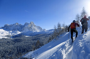
Back-country skiing • Val di Sole
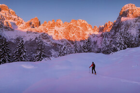
An easy itinerary in the charming Val di Rabbi with the added bonus of having a splendid mountain hut located along the route which also remains open in winter (the Malga Monte Sole Alta farmhouse).
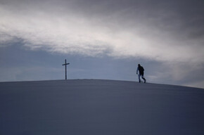
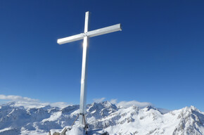
The Monte Sole peak is ideal for winter ascents and to enjoy the snow overlooking the splendid Val di Rabbi.

Derived from the technical difficulty and the stamina requirements.
Remember that the stability of the snow cover is subject to sudden and unpredictable changes and shifts. Always check the local avalanche bulletin (www.meteotrentino.it or any other service that suits your needs) before departure and make sure to collect all possible information about current conditions at the Alpine Guides office (http://www.guidealpinevaldisole.it).
GPS tracks are only indicative of the most common routes and should not be blindly followed without first verifying the current slope and terrain conditions.
Note that the practicability of mountain routes is strictly linked to prevailing conditions and is therefore influenced by natural phenomena, environmental changes, and weather conditions. For this reason, the information contained on this page may have changed. Before setting out on a route, make sure the path is still accessible by contacting the owner of the hut, the alpine guides, or visitor centers of natural parks, tourist offices, or local entities' info offices.
For all ski mountaineering activities, appropriate clothing is strongly recommended. Skiers should consider that temperatures can drop rapidly and clothing must also be suitable for snowy conditions (such as waterproof Gore-Tex jackets). Additionally, gloves, hat, sunglasses, and sunscreen should always be part of every off-piste skier's basic equipment.
It is also important to remember that ski boots that are too tight or insufficiently waterproof can cause frostbite.
It is MANDATORY to carry an avalanche rescue kit consisting of an ARVA, probe, and shovel (this is also available for rent).
A suitable helmet and other safety equipment are also highly recommended (avalanche airbags, etc.).
In case of hard snow or ice, ski crampons are advised.
Derived from the technical difficulty and the stamina requirements.