Jacopeo d'Anaunia Path - I stage
Pilgrim trail • Val di Non
Jacopeo d'Anaunia Path - I stage
Woods, meadows, villages and small churches that are jewels of sacred art. Paths and places crossed by pilgrims for 500 years!
<p>In this first stage, we find Maso San Bartolomeo in Romeno where we can admire the precious and ancient church of the hospice for pilgrims, documented back in 1213. Continuing a little further we reach the church of S. Antonio in Romeno, precious for the cycle of frescoes on the outer walls dedicated to the most famous miracle attributed to St. James of Compostela, commonly known as the legend of the hanged. Other important signs concerning the devotion to San Giacomo di Compostela are to be found in Fondo where we can admire various frescoes dedicated to the Saint.</p> <p>Overall, this beautiful stage is quite challenging both for its length and for the altitude gain, but it does not have very steep climbs except for the short one that leads from the gorge of San Romedio to Salter. The average walking time, excluding breaks, is around 7-8 hours, depending on physical condition and walking speed.</p>
Jacobean Route of Anaunia - Stage 1, PART 1 from Sanzeno to Fondo

APT Val di Non Verified partner
-
 Photo: Paolo Menapace, Associazioni Anaune Amici del Cammino di Santiago
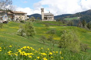
From Sanzeno to Fondo. Woods, meadows, villages and small churches that are little gems of sacred art. Paths and places crossed by pilgrims for 500 years!
In this first part of the first stage we find the San Bartolomeo farmstead in Romeno, where we can admire the precious and ancient small hospice church for pilgrims documented already in 1213. Continuing a bit further we reach the small church of St. Anthony in Romeno, precious for showing outside a cycle of frescoes dedicated to the most famous miracle attributed to Saint James of Compostela, commonly called the legend of the hanged man. Other important signs concerning the devotion to Saint James of Compostela can be found in Fondo where we can admire various frescoes dedicated to the Saint.
Overall, this beautiful stage is quite demanding both for the length and for the elevation gain, but does not present very steep climbs except for the short one from the San Romedio gorge to Salter. Average walking times, excluding breaks, are around 5 hours, depending on physical training and personal walking attitude.
Author’s recommendation
Before starting the Jacobean Route request your Pilgrim's Credential, it will be sent free directly to your home! To request it write to the Val di Non Tourism Board: info@visitvaldinon.it
The stamp to be placed on the Pilgrim's Credential can be found at:
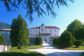
Sanzeno - Church of the Holy Martyrs
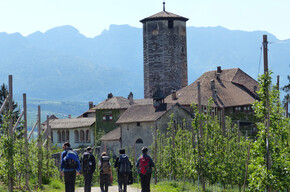
Romeno - Church of San Bartolomeo
Romeno - Church of Sant'Antonio Abate, at the Cemetery (on request)
Cavareno - Church of SS. Fabian and Sebastian (on request)
Fondo - Parish Church of San Martino (contact Don Dario Pret 360 791509)
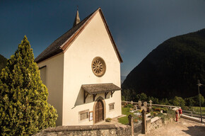
Fondo - Santa Lucia Church (on request, contact Don Dario Pret 360 791509)
APT Val di Non Verified partner
Derived from the technical difficulty and the stamina requirements.
Track types
Show elevation profileSafety information
The route is well marked, with the presence of the yellow stylized shell symbol and various signs indicating the way. It follows ancient connecting trails between small villages and ancient roads that led to the Sanctuaries, pilgrimage destinations. There are short stretches of roads with low vehicle traffic.
As you can imagine, the passability of the routes in a mountain environment is strictly linked to current conditions and therefore depends on natural phenomena, environmental changes, and weather conditions. For this reason, the information contained in this sheet may have changed. Before leaving, check on the status of the path by contacting the refuge managers along your route, alpine guides, visitor centers of natural parks, and tourist offices.
Tips and suggestions
www.santiagoanaunia.itRoadbook
The first stage of the route starts from the Basilica of the Holy Martyrs of Sanzeno, the main place for Christianity in our valley, and ends at the village of Fondo.
Leaving the Basilica (altitude 630 m) you climb up to the Rhaetian Museum and take the path along the rock face leading to the Sanctuary of San Romedio. A few hundred meters before the Sanctuary, take the ascent that leads to Salter and then following the new cycle path we reach the San Bartolomeo farmstead in Romeno (progressive 7.6 km altitude 906 m). Continuing a little further we reach the small church of St. Anthony in Romeno, precious for showing outside a cycle of frescoes dedicated to the most famous miracle attributed to Saint James of Compostela, commonly called the legend of the hanged man.
Continuing and crossing beautiful meadows we arrive at Fondo (progressive 15.1 km altitude 985 m) where we can admire various frescoes with the Jacobean theme (mainly depicting Saint James of Compostela); if time allows, we can visit the ancient church of Santa Lucia.
Texts by Donato Iob
Anaune Association Friends of the Camino de Santiago
Casa De' Gentili
Museo Retico
Chiesa dei SS. Bartolomeo e Tommaso a Romeno
Sant'Antonio Abate
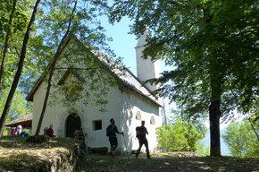
Santa Lucia
Chiesetta di S. Lucia a Fondo
Santuario di Senale
Chiesa di San Martino
Public transport
Public-transport-friendly
From Trento, take the local train to Dermulo station. Here you take the connection with the line bus no. 630.
Directions
From the Brenner motorway A22 take the Trento Nord exit and continue towards Val di Non on SS43. At Dermulo take the right fork towards Passo della Mendola until you reach Sanzeno after a few kilometers.Parking
Free parking at the Basilica of the Holy Martyrs of Sanzeno.Coordinates
Book recommendation by the author
The official guide of the Camino Jacopeo d'Ananunia is recommended, complete with route information and historical and cultural details, as well as the official website of the route: www.santiagoanaunia.it
Author’s map recommendations
Equipment
Anyone who sets out on the route and wishes to reach their destination without problems must wear a good pair of comfortable shoes, preferably with a sculpted sole (such as Vibram) and ankle protection (like hiking boots), but in which the foot is firmly held to avoid blisters or, worse, risk sprains. It is also advisable to have a stick (or better still telescopic poles) to help on the path, especially in some more challenging sections.Localization
Derived from the technical difficulty and the stamina requirements.
Weather at the starting point
Statistics
You may also like ...