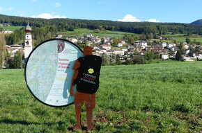
Jacopeo d'Anaunia Path – V stage
Pilgrim trail • Val di Non
Jacopeo d'Anaunia Path – V stage
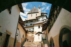
The fifth stage winds by castles and churches in the central area of Val di Non in the stretch between its capital Cles and Flavon.
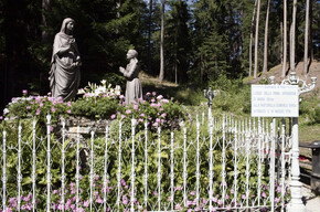
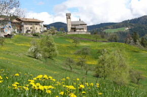
With this stage we cross the central part of Val di Non and come across castles and churches in the various villages we pass through. There is the church of S. Vigilio in Cles, one of the oldest in the valley with various frescoes dating back to the thirteenth century, Castel Valer in Tassullo, Castel Nanno in Nanno, the old church of S. Paolo in Pavillo dating back to the fifteenth century, the church of S. Emerenziana at the entrance to the Val di Tovel, the church of S. Giorgio in Terres with Romanesque frescoes of 1100-1200).
Cammino Jacobeo d'Anaunia - stage 5

APT Val di Non Verified partner
-
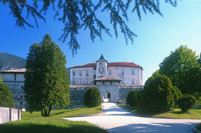
 Castel ValerPhoto: Paolo Menapace, Associazioni Anaune Amici del Cammino di Santiago
From Cles to Flavon. The fifth stage unfolds, between castles and churches, in the central area of the Val di Non in the stretch between Cles, the capital of the valley, and Flavon.
Author’s recommendation
The stamp to be placed on the Pilgrim's Credential can be found at:
Tassullo - church of S. Vigilio
Pavillo - church of S. Paolo
Tuenno - church of S. Orsola and Companions
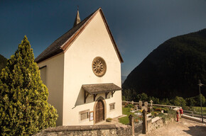
Flavon - church of S. Giovanni Battista
APT Val di Non Verified partner
Derived from the technical difficulty and the stamina requirements.
Track types
Show elevation profileSafety information
The Way is well signposted, with the presence of the stylized yellow shell symbol and various signs indicating the route. You walk along ancient linking paths between small villages and old roads that led to the Sanctuaries, pilgrimage destinations. There are short stretches of roads with low vehicular traffic.
As you can imagine, the passability of the routes in a mountain environment is strictly linked to current conditions and therefore depends on natural phenomena, environmental changes, and weather conditions. For this reason, the information contained in this sheet may have changed. Before setting off, check the condition of the route by contacting the refuge managers on your route, mountain guides, visitor centers of natural parks, and tourist offices.
Tips and suggestions
Roadbook
Leaving the parish church of Cles, continue towards Pez where you can visit the church of S. Vigilio, one of the oldest in the valley. Continue, following the arrow and yellow shell, towards Maiano, from where you enjoy a spectacular view of Lake S. Giustina. Continue and after crossing the state road, take the Roman road up to Rallo. Then pass Sanzenone and through farm roads reach Tassullo with its main churches dedicated to the Assumption and S. Vigilio. After the hamlet of Campo, take the "Val dela Paia" to the left, and after admiring Castel Valer and its beautiful hexagonal tower, arrive at Nanno.
After the village, climb to Castel Nanno, then Pavillo and through the "Dos de Lorè" you reach Tuenno following an ancient connection. Now head towards S. Emerenziana and descend towards the homonymous power plant and then along the Tresenica stream to the bridge. It is recommended to carefully climb the provincial road up to Terres; there, climb up to the "Lez" irrigation canal and follow it, immersed in the woods, to reach the descent leading to Flavon, end of stage.
If this stage seems too challenging, it can be interrupted at Tuenno, returning directly to Cles via the cycle path (about 15.5 km).
Texts by Donato Iob
Associazione Anaune Amici del Cammino di Santiago
Chiesa dei SS. Pietro e Paolo a Maiano
Chiesa di San Vigilio a Tassullo
Chiesa di S. Paolo a Pavillo
Chiesa S. Orsola e compagne
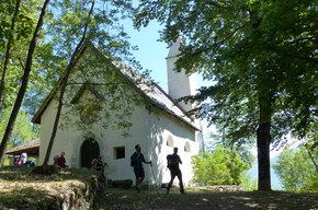
Eremo di S. Emerenziana a Tuenno
Santi Filippo e Giacomo
San Giorgio
Chiesa di S. Giovanni Battista a Flavon
Public transport
Public-transport-friendly
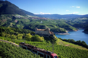
A local train connects Trento to the town of Cles in about 1 hour.
Directions
From the Brenner motorway A22 take the Trento Nord exit and continue in the direction of Val di Non until you reach the village of Cles.Parking
Free and public parking in Piazza Fiera near the Carabinieri barracksCoordinates
Book recommendation by the author
The official guide to the Camino Jacobeo d'Ananunia is recommended, complete with route directions and historical and cultural insights, as well as the official walk website: www.santiagoanaunia.it
Author’s map recommendations
Equipment
Anyone starting the walk and wishing to reach their destination without problems should wear a good pair of comfortable shoes, preferably with a sculpted sole (like Vibram) and ankle protection (such as hiking boots), but ones in which the foot is firmly held to avoid blisters forming or worse, risk a sprain. It is also advisable to have a walking stick (or even better, telescopic poles) to help along the way, especially in some more challenging sections.Localization
Derived from the technical difficulty and the stamina requirements.
Weather at the starting point
Statistics
You may also like ...