Passo Manghen - Fiemme

Race cycling • Val di Fiemme

Race cycling Race cycling  · Fiemme and Cembra Valleys

Passo Manghen - Fiemme

Responsible for this content
VisitTrentino Verified partner 
  • Passo Manghen - Fiemme
    Passo Manghen - Fiemme
    Photo: VisitTrentino, VisitTrentino
Map / Passo Manghen - Fiemme

Selected alternatives for you
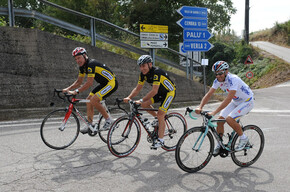
    The climb of Passo Manghen from Molina di Fiemme tells the story of men and cyclists. A road that in its altimetry speaks of the character of mountain men. It is a path that gives great satisfaction to cyclists who are wise enough to take on the challenge without pride.
    moderate
    Distance 16 km
    2:52 h
    1,396 m
    175 m
    2,042 m
    810 m
    Profile picture of VisitTrentino
    Author
    VisitTrentino
    Responsible for this content
    VisitTrentino  Verified partner 
    Difficulty
    moderate
    Overall difficulty
    moderate

    Derived from the technical difficulty and the stamina requirements.

    Experience
    Landscape
    Highest point
    2,042 m
    Lowest point
    810 m
    Best time of year
    Jan
    Feb
    Mar
    Apr
    May
    Jun
    Jul
    Aug
    Sep
    Oct
    Nov
    Dec

    Track types

    Show elevation profile

    Safety information

    Please note that the practicability of the itineraries in a mountain environment is strictly linked to the contingent conditions and is therefore influenced by natural phenomena, environmental changes and weather conditions. For this reason, the information contained in this page may have changed. Before leaving for a tour, make sure the path you will approach is still accessible by contacting the owner of the mountain hut, the alpine guides or the visitor centres of the nature parks, the info offices of the local tourist board.

    Roadbook

    On this road, during the Giro d’Italia of 1976 Francesco Moser confirmed his indomitable and courageous personality. On the dirt road of the Manghen, the young champion from Palù, after the long stage through the Dolomites, managed to keep up with the pace of the best cyclists. Then on the stretch downhill he fired up the crowd, once again displaying his fighting spirit.

    This is a road of real men, like the firefighters of Molina, who in 1954 along with their colleagues from Telve began working on a road-link that was completed in 1958. A lot of progress has been made since then and the Manghen has become legendary.

    The climb up from Molina deserves respect. At the beginning the slopes are not prohibitive, but after 8 kilometres, at Ponte delle Stue, the road shows its true nature. The bicycle darts up and the front wheel aims for the sky. The muscles are taut under the effort on slopes always around 10 percent. The roadway is wide and smooth, with a climb that doesn't yield until you reach the Pass.

    The Manghen trail was travelled for centuries by shepherds and "cromeri", the travelling merchants who traversed Europe and who would find refreshment in the dairy huts. Even today, these places offer the same hospitality. Because a tired cyclist is still a mountain man.

    Rest stop
    Tip
    Nearby
    Top Partner
    Waypoint
    Start point
    End point
    Low point
    High point
    Forecast
    Today {low} to {high} and {precipitation} of {precipitation_type}
    show {x} more
    Photo
    Video

    Coordinates

    DD
    46.270840, 11.422777
    DMS
    46°16'15.0"N 11°25'22.0"E
    UTM
    32T 686681 5126993
    w3w 
    ///elector.prowled.spout
    Get there by train, car, bike, or on foot!

    Similar routes nearby

    • Giro d'Italia climb - Manghen Pass
    • Giro d'Italia climb - Lavazè Pass
    • Latemar Tour
    • Val di Cembra
    • Giro d'Italia climb - Malga le Buse del Sasso
     These suggestions were generated by our system
    Difficulty
    moderate
    Overall difficulty
    moderate

    Derived from the technical difficulty and the stamina requirements.

    Distance
    16 km
    Duration
    2:52 h
    Ascent
    1,396 m
    Descent
    175 m
    Highest point
    2,042 m
    Lowest point
    810 m

    Weather at the starting point

    10-day forecast

    Statistics

    • Content
    • Show images Hide images
    Features
    2D 3D
    Maps and trails
    Nothing selected - click and drag in the elevation profile to zoom
    Distance
    Duration
    Ascent
    Descent
    Elevation profile


    You may also like ...

    164 results
    Fai-Andalo della Paganella

    Fai-Andalo della Paganella

    Roadbike - Pergine Valsugana - Val dei Mocheni

    Roadbike - Pergine Valsugana - Val dei Mocheni

    Sellaronda

    Sellaronda

    Lavarone - Carbonare - Pedescala - Rotzo - Roana - Passo Vézzena -...

    Lavarone - Carbonare - Pedescala - Rotzo - Roana - Passo Vézzena -...

    Roadbike - Lakes Levico and Caldonazzo - and Tenna Hill

    Roadbike - Lakes Levico and Caldonazzo - and Tenna Hill

    Passo del Tonale

    Passo del Tonale

    Madonna di Campiglio

    Madonna di Campiglio

    Campionissimi - Palù di Giovo

    Campionissimi - Palù di Giovo

    Fai-Andalo della Paganella

    This route follows the Valle di Non state road on the outskirts of...

    Read more ...

    Roadbike - Pergine Valsugana - Val dei Mocheni

    Medium difficulty tour to discover the beautiful and green Valle dei...

    Read more ...

    Sellaronda

    The Sellaronda, or Tour of the Four Passes, is one of the most...

    Read more ...

    Lavarone - Carbonare - Pedescala - Rotzo - Roana - Passo Vézzena -...

    Read more ...

    Roadbike - Lakes Levico and Caldonazzo - and Tenna Hill

    Easy route, which allows you to admire the landscapes of the lakes of...

    Read more ...

    Passo del Tonale

    On the road of the White War. The climb up Passo del Tonale is full...

    Read more ...

    Madonna di Campiglio

    In 2015, the Giro d’Italia arrived at Patascoss, starting point of...

    Read more ...

    Campionissimi - Palù di Giovo

    The big Champions ascent is the road leading from San Michele...

    Read more ...

    Race cycling