Avalanche conditions
most recent, highest rating
{numRegions} bulletins: highest rating
{numRegions} bulletins: most recent, highest danger levels
Snowshoeing • Val di Non
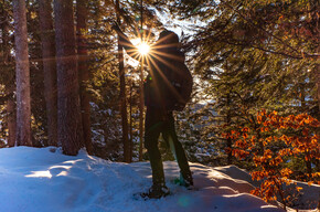
Il Monte Roen è un classico sia in estate che in inverno. Le pendenze mai eccessive, gli ottimi rifugi lungo il percorso e il panorama a 360° ne fanno un must!
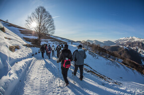
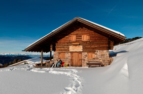
Dal comodo parcheggio al Passo della Mendola si segue costantemente il ben segnalato sentiero SAT 500 fino alla cima. Essendo una meta frequentata la traccia da seguire è sempre ben evidente e la neve battuta. I rifugi Mezzavia e Malga di Romeno sono sempre aperti e ottimi punti per un pranzo o una semplice merenda in quota.


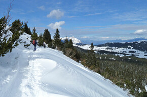
Mount Roen is a classic in both summer and winter. The never-excessive inclines, excellent huts along the way, and 360-degree views make it a must!
From the convenient parking area at Mendola Pass, follow the well-marked SAT 500 trail steadily to the summit. Being a popular destination, the trail to follow is always well marked and the snow groomed. The Mezzavia and Malga di Romeno refuges are always open and excellent spots for lunch or a simple snack at altitude.
Those who do not have snowshoes can rent them from Nolo Ski Gianni at the start of the Roen lifts. From the pass, continue for 1 km following the trail signs and then park near the ski lift.
Those who want to reduce the elevation gain of the hike can choose to take the first section up to the Mezzavia Refuge by chairlift.
Derived from the technical difficulty and the stamina requirements.
Always consult the avalanche bulletin here before embarking on a snow hike!
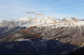
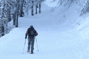
From the chairlift, take the track on the right of the slope that climbs into the forest to reach the Mezzavia Refuge. From here, proceed following the path with SAT 500 signs that climbs alternating between medium-steep sections and flatter stretches to then reach in another hour's walk a wide, soelggiated clearing where the Malga di Romeno stands. After a well-deserved break on the terrace or inside in front of the warmth of the stove, you continue for the final, more challenging section.
From the Malga you still follow the SAT 500 trail marker, which immediately becomes very steep. The trail narrows and winds among the characteristic mugho trees that distinguish the high altitude slope of Mount Roen. The fatigue of this last pora of walking that separates the Malga di Romeno from the summit of Mount Roen is then repaid by the incredible panorama overlooking the Adige Valley and the Dolomites.
The return is made by the same route as the outward journey.
Public-transport-friendly
From the south it can be reached by Trentino Trasporti bus route 630.
From the municipality of Appiano, on the other hand, the Mendola Funicular of SAD Trasporti goes up.
From the Trento Nord exit of the A22: continue on the SS43 state road north toward Cles. before Cles at the crossroads in the village of Dermulo, keep right to take the SS42 in the direction of Passo della Mendola
From Bolzano continue to the nearby village of Appiano and here take the Mendola Pass Road to the pass.
There are many free parking lots near the pass
4Land, hiking map number #155 scale 1:25,000
4Land Hiking Map No. 155
Winter boots, poles and snowshoes. Use crampons in case of icy snow. In case of fresh snow, gaiters are helpful. Don't forget to bring a spare T-shirt.
Localization
Derived from the technical difficulty and the stamina requirements.