Falesia Marino Stenico - 36 vie dal 4c al 7c
Alpine climbing • Val di Non
Falesia Marino Stenico - 36 vie dal 4c al 7c
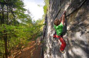
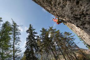
Storica falesia detta anche "Sedruna" frequentata perlopiù in estate grazie all'ombra e al clima fresco della zona.
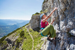
Uno dei maggiori pregi di questa falesia storica è la comodissima base che permette a famiglie con bambini e passeggini di sostare comodamente sulla terrazza in ghiaino sottostante ai tiri. Non mancano panche e tavole in legno per un sano pic nic.
Marino Stenico Crag - 36 routes from 4c to 7c

APT Val di Non Verified partner
-
 Photo: APT Val di Non, APT Val di Non
Author’s recommendation
APT Val di Non Verified partner
Derived from the technical difficulty and the stamina requirements.
Track types
Show elevation profileRest stops
Ristorante La MontesònPizzeria Ristorante "Al Folon"
Ristorante Il Falchetto
Safety information
The correct equipment, use of a helmet, the right skills, and a high level of attention are fundamental for practicing this sport.Tips and suggestions
The crag is published in the climbing guide of South TyrolRoadbook
The crag is located beside a comfortable dirt road on a false flat that connects the villages of Fondo and Malosco. It is a classic walk for locals and is appreciated by tourists thanks to its exposure which makes it particularly cool in summer months. In fact, the crag can only be visited in the warmer months where elsewhere the heat makes practicing this sport impossible.
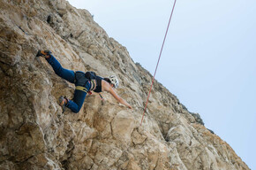
This crag satisfies both beginners and more experienced climbers. The difficulties range from the classic 4th degree up to a maximum of 7c with a large prevalence of routes in the 5th and 6th degrees. The bolting was done with resin bolts spaced properly to allow everyone to climb safely.
The climbing is often technical on slopers, vertical sections, and pockets on excellent limestone. The rock is very clean thanks to constant maintenance and years of frequentation. Some passages, particularly on the easier routes, may be polished but without causing inconvenience.
The length of the routes is about 20 meters.
1 Perlotto 18 m 5c
2 Silicone 20 m 6a
3 Diedrite 15 m 4c
4 Gri gri 15 m 5c
5 Isterica 15 m 5a
6 Derby flex 15 m 5c
7 Sax e sex 18 m 5a
8 Ottone 20 m 5b
9 Luna 20 m 6b
10 Del francese 20 m 6a
11 Freccia rossa 20 m 6b
12 Topo crudele 20 m 6c
13 Speady 20 m 6a+
14 Naomi 15 m 6a
15 Rosso di sera 22 m 6a
16 Classic magic 22 m 5c
17 Tempo per respirare 22 m 6a
18 Neverland 22 m 6a
19 senza nome 22 m 6a
20 Senza parole 22 m 6b+
21 Sogni di un viaggio 18 m 7c
22 Top secret 18 m 7a+
23 Smeralda 18 m 7a+
24 Tempi duri 18 m 7a+
25 Max 24 m 6c+
26 Crisalide 24 m 6b
27 Nuova piloni 24 m 7a
28 Xy 24 m 7c
29 Tuoni e fulmini 24 m 7c
30 Frutti di bosco 22 m 7b
31 Colibrì 22 m 6b+
32 Tre sette 20 m 6b
33 Farfallina 18 m 6b
34 Super 18 m 6c
35 Metal racket 20 m 7a
36 Little blocks 20 m 7b+
Directions
From Fondo: head towards Lago Smeraldo and continue to the end of the road where the dirt road begins towards Malga di Fondo. On the right there is a dirt parking area. Then continue on foot for about 10 minutes on the dirt road and a path that cuts a hairpin to reach the crag more directly. If you have a stroller just follow the dirt road instead of cutting through the path.
From Malosco: leave the car in Loc. Fontanelle at the edge of the forest and continue on the comfortable dirt road that gently descends to the crag in about 20 minutes. The dirt road is suitable for any type of stroller.
Parking
Fondo: dirt parking at the end of the Lago Smeraldo road
Malosco: parking in Loc. Fontanelle
Coordinates
Equipment
Those who climb know exactly what equipment is necessary.Localization
Derived from the technical difficulty and the stamina requirements.
Weather at the starting point
Statistics