Jacopeo d'Anaunia Path - III Stage
Pilgrim trail • Val di Non
Jacopeo d'Anaunia Path - III Stage
This part of the Path leads us from the Val di Rumo, through Val di Bresimo, into Val di Sole and gives us suggestive views of the various villages crossed. There is no shortage of the jewels of a sacred art that offers ongoing stimuli.
<p>At the beginning of this stage you can decide to either end the Cammino and go back to Sanzeno following the Variant of Stage 3 or to continue on the Stage 3 of the Cammino Jacopeo.</p> <p>All'inizio di questa tappa si può decidere se concludere il Cammino andando a Sanzeno grazie alla Variante della tappa 3 oppure proseguire con la Tappa numero 3.</p> <p>A fairly demanding stage in terms of length. It can be divided in two with an intermediate stop in Cis.</p> <p>At this stage you have the chance to walk back to Sanzeno and finish the Jacope d'Anaunia Path in just 3 days. Here the details to the variant of III stage!</p> <p> </p> <p>On the Path you will find in Preghena the sixteenth-century church of St. Anthony with its external facade characterised by fifteenth-century frescoes depicting St. Sebastian, St. Christopher and St. Bernard. In Baselga dei Bresimo there is the church/sanctuary of Santa Maria Assunta. In San Giacomo di Caldes there is the parish church dedicated to San Giacomo il Maggiore (of Compostela).</p>
Camino Jacopeo d'Anaunia - Stage III

APT Val di Non Verified partner
-
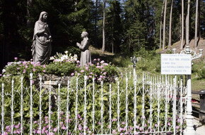
 Chiesa S. Maria Assunta a Baselga di BresimoPhoto: APT Val di Non
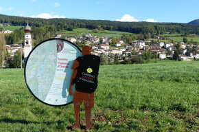
From Rumo to Terzolas in Val di Sole. This Camino route takes us from the Val di Rumo, through the Val di Bresimo, into the Val di Sole to discover suggestive glimpses in the various villages crossed. Not missing are the jewels of sacred art that offer continuous stimuli.
At the start of this stage you can decide whether to finish the Camino by going to Sanzeno or continue with Stage number 3.
Stage quite demanding because of the length. It can be divided into two with an intermediate stop at Cis.
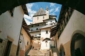
On the Camino you encounter in Preghena the 16th-century church of St. Anthony with an external facade characterized by 15th-century frescoes depicting St. Sebastian, St. Christopher, and St. Bernard. At Baselga di Bresimo there is the church/shrine of Santa Maria Assunta. At San Giacomo di Caldes there is the parish church dedicated to Saint James the Greater (of Compostela).
Author’s recommendation
The stamp to be placed on the Pilgrim's Credential can be found at:
Baselga di Bresimo - church/shrine of Santa Maria Assunta (for opening the church ask the lady in the house on the left of the church)
San Giacomo di Caldes - at the rectory or at Penasa Maria
Terzolas - at the bar la Torraccia (closed on Wednesdays)
Terzolas - Capuchin friars' convent (hospitality at guesthouse)
APT Val di Non Verified partner
Derived from the technical difficulty and the stamina requirements.
Track types
Show elevation profileSafety information
The Camino is well marked, with the presence of the stylized yellow shell symbol and various signs indicating the way. You travel ancient connecting paths between small villages and old routes that led to the Shrines, pilgrimage destinations. There are short sections of roads with low vehicle traffic.
As you can imagine, the passability of the routes in a mountain environment is closely linked to current conditions and therefore depends on natural phenomena, environmental changes, and weather conditions. For this reason, the information contained in this sheet may have changed. Before leaving, check the state of the route by contacting the refuge managers along your path, alpine guides, nature park visitor centers, and tourist offices.
Tips and suggestions
Roadbook
After leaving Rumo on a stretch of road and a beautiful path through the woods, you arrive at the so-called Mezzalone, in Preghena. You go back up a stretch of the provincial road towards Bresimo and immerse yourself in a quiet landscape that preserves naturalistic and ethnographic aspects similar to the past. The first village encountered is Baselga di Bresimo, which hosts the important church of Santa Maria Assunta (a national monument) famous for containing 15th-century frescoes. After Bevia and Fontana Nuova, near the church of Bresimo, take the direction to the Segheria Veneziana and follow the noisy Barnès to Cis. Here we take the Roman road which, through orchards and woods, leads to San Giacomo di Caldes.
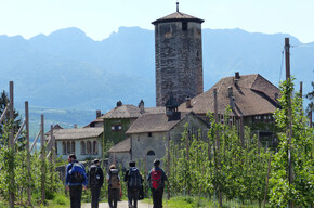
You reach Samoclevo and then Terzolas, which marks the end of the stage.
Texts by Donato Iob
Anaune Association Friends of the Camino de Santiago
Chiesa di S. Maria di Bresimo
Chiesa di San Giacomo
Chiesa di San Nicolò e la Torraccia
Directions
From the Brenner motorway A22 take the Trento Nord exit and continue towards Val di Non on SS43. Arriving at the Mostizzolo bridge turn right and follow clear signs to Rumo.Parking
Free and public parking at the rural bank office in Mione di Rumo.Coordinates
Book recommendation by the author
The official guide to the Camino Jacopeo d'Ananunia is recommended, complete with route directions and historical and cultural insights, and the official website of the camino: www.santiagoanaunia.it
Author’s map recommendations
Equipment
Anyone who sets out and wishes to reach their destination without issues must wear a good pair of comfortable shoes, preferably with a sculpted sole (like Vibram) and ankle protection (like hiking boots), but with the foot firmly held to avoid blisters or, worse, risking a sprain. It is also advisable to equip yourself with a stick (or better yet, telescopic poles) to help during the walk, especially in some more challenging sections.Localization
Derived from the technical difficulty and the stamina requirements.
Weather at the starting point
Statistics
You may also like ...