Jacopeo d'Anaunia Path – VI stage
Pilgrim trail • Val di Non
Jacopeo d'Anaunia Path – VI stage
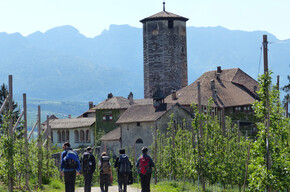
This is a very scenic stage that runs along the final part of the right side of Noce and then climbs up on the opposite side to Vigo di Ton.
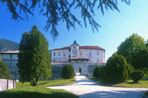
<p>This stage is quite demanding due to the altitude difference to encounter and overcome, and can be shortened if necessary by stopping at Crescino (after km 12.5).</p> <p>In this sixth stage of the Path we take in Castel la Santa, once a monastery and hermitage of the Teutonic Knights; the Hermitage of S. Pancrazio, an ancient hermitage that offered accommodation to travellers on one of the ancient mountain roads that led to Madonna di Campiglio; in Segonzone we find the ancient church of SS. Filippo and Giacomo and Castel Belasi. At the end of the stage, Castel Thun, a splendid mansion that gave birth to the powerful Thun family and at least ten bishops in Trentino and Austria.</p>
Camino Jacobeo d'Anaunia - Stage VI

APT Val di Non Verified partner
-
 Photo: Paolo Menapace, Associazioni Anaune Amici del Cammino di Santiago
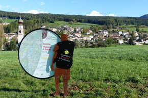
From Flavon to Vigo di Ton.
A very panoramic stage that follows the final part of the right side of the Noce river and then climbs the opposite slope up to Vigo di Ton.
This stage is quite challenging due to the elevation differences overcome and can be shortened by stopping at Crescino (12.5 km).
In the sixth stage of the Camino, we encounter Castel la Santa, once a monastery and hermitage of the Teutonic Knights; the Hermitage of St. Pancras, an ancient hermitage that offered lodging to travelers on one of the ancient mountain roads that led to Madonna di Campiglio; in Segonzone, there is the ancient little church of Saints Philip and James and Castel Belasi. At the end of the stage, Castel Thun, a splendid noble residence that gave birth to the powerful Thun family and at least ten bishops in Trentino and Austria.
Author’s recommendation
The stamp to be placed on the Pilgrim's Credential can be found at:
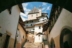
Vigo di Ton - Pieve di Santa Maria Assunta
Vigo di Ton - Castel Thun, at the ticket office
APT Val di Non Verified partner
Derived from the technical difficulty and the stamina requirements.
Track types
Show elevation profileSafety information
The Camino is well marked with the presence of the stylized yellow shell symbol and various signs indicating the route. It follows ancient connecting paths between small villages and old routes that led to sanctuaries, pilgrimage destinations. There are short stretches of roads with low vehicle traffic.
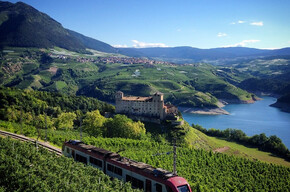
To overcome a non-pedestrianable section, it is necessary to use the local train with ascent to Crescino and descent to Masi di Vigo. Attention, stops are on request! To get off at Masi di Vigo, you must book the stop by pressing the appropriate button present in all carriages.
>> Local train timetable for Crescino - Masi di Vigo route
As you can imagine, the traversability of the routes in a mountain environment is strictly linked to contingent conditions and therefore depends on natural phenomena, environmental changes and weather conditions. For this reason, the information contained in this sheet may have changed. Before leaving, check the status of the route by contacting the refuge managers along your route, alpine guides, visitor centers of natural parks, and tourist offices.
Tips and suggestions
Roadbook
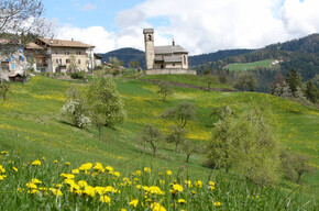
The sixth stage begins by returning to the Flavon pine forest, passing the small lake and reaching Cunevo. The pilgrim heads towards "Castel la Santa," once a monastery and hermitage of the Teutonic Knights. Then continue towards the Termon chapel dedicated to Pope John XXIII and following a forest road uphill and a short descent, you arrive at the Hermitage of St. Pancras, an ancient hermitage located above Campodenno in a beautiful pinewood. Passing it, you follow a farm road through orchards and woods leading to Lover, descend to Segonzone and then to Crescino, passing a small chapel dedicated to "Salve Regina."
With the local train from Crescino to Trento, you cross the Noce river in just a few minutes and descend to the Masi di Vigo station on the opposite slope of the valley and then climb towards the homonymous village. Then a forest road, first uphill and then downhill, will lead to the gates of Vigo di Ton at the foot of Castel Thun, end of the stage.
This stage is quite challenging due to the elevation differences overcome and can be shortened by stopping at Crescino (12.5 km).
Text by Donato Iob
Association Anaune Friends of the Camino de Santiago
Chiesa del ritrovamento di Santa Croce
San Lorenzo
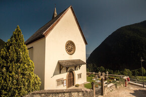
Church of St. Pancrazio
Santi Filippo e Giacomo
Belasi Castle
Thun Castle
Pieve di Santa Maria Assunta
Directions
From the Brenner motorway A22, take the Trento Nord exit and continue towards Val di Non and Val di Sole on SS43. After the locality Rocchetta, follow the signs for Denno and then continue on SP73 to Flavon.Parking
There are free and open parking spaces under the church of Flavon.Coordinates
Book recommendation by the author
The official guide of the Camino Jacobeo d'Anaunia is recommended, complete with indications related to the route and historical and cultural insights, and the official website of the camino: www.santiagoanaunia.it
Author’s map recommendations
Equipment
Anyone who sets out on the way and wishes to reach their destination without problems must wear a good pair of comfortable shoes, preferably with a lug sole (like Vibram) and ankle protection (like hiking boots), but in which the foot is well secured to avoid blisters or, worse, risk of sprains. It is also advisable to carry a stick (or even better, telescopic poles) to help while walking, especially in some more challenging passages.Localization
Derived from the technical difficulty and the stamina requirements.
Weather at the starting point
Statistics
You may also like ...